Last week we launched our new survey product, I-Site Drive. It connects a custom vehicle mount with specific software to enable continuous acquisition of data using an I-Site laser scanner. I’ve had the pleasure of ‘test driving’ I-Site Drive at several Australian mine sites. Here’s my experience of the system.
Tracking stockpile volumes is on the job sheet for surveyors almost everywhere. Sites either rely on GPS and total stations or use a laser scanner. The downside of the GPS-total station approach is walking over stockpiles; a very unsafe practice. Measuring with a laser scanner in stop-go mode captures a significant amount of excess data; this means more time in the field and in post processing.
Our customers liked the concept of continuous operation and our R&D team got to work. The result is I-Site Drive.
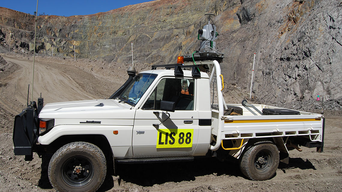
So how does it work? I-Site Drive links an I-Site laser scanner with GPS data to generate a stockpile profile while driving around the perimeter without stopping. The key lies in the base of the custom vehicle mount where the Inertial Navigation System (INS) is incorporated. The INS enables continuous acquisition and – best of all – registers the data into real world coordinates. The INS communicates with the I-Site scanner which in turn transfers data to the tablet software in real time. Connection with an RTK GPS system ensures the location is accurate.
Setting up the system is incredibly easy. Any surveyor can install the scanner on the mount, connect the power and network, attach the RTK GPS and initialise scanning on the tablet computer, all in under 5 minutes. There’s no need to calibrate I-Site Drive. It’s done automatically as you drive to your first scanning location.
 Field trials helped R&D finetune the system to the point that travelling at 14km/h was identified as the sweet spot to acquire a uniform grid of points. This is equivalent to a resolution 2 scan with the I-Site 8820 laser scanner. Depending on the required data density, driving at speeds up to 40km/h is fine for general pickups.
Examining the data collected by the scanner in real time on the tablet is a standout feature. It was easy to spot data shadows. We could either stop immediately, reverse and capture the data, or simply drive around again.
Using I-Site Drive a typical stockpile volume survey took us 45 minutes. This compares to 4 hours using other techniques.
Back in the office, data processing is quick and easy. Because the data already has coordinates assigned, registration is just translating the data from UTM to local coordinates. No other registration is needed and volumes can be extracted in minutes.
You can also use the I-Site laser scanner for all of your other survey tasks. Install it on the tripod, use stop-go … listing all the applications here could take all day! Let’s just say the versatility of the system makes it an easy sell to the number crunchers.
I-Site Drive is ideal for quickly gathering survey data. It’s quick and easy to get started, the software is intuitive and data is immediately ready for processing. In my experience, I-Site Drive is the system to have on side to tick off the never-ending survey tasks on your job sheet!

Jordan Herrmann
I-Site Sales Consultant
February 17, 2015
For additional information about Maptek, including use of the Maptek logo, product images and reproduction of case studies, please direct inquiries to Global Marketing Communications Manager jane.ball@maptek.com.au