Maptek takes to the air
Monday, February 24th, 2014
Maptek has made a significant investment in DroneMetrex, an Adelaide-based startup company that has developed innovative new technology for aerial photogrammetric mapping from small drone aircraft.
The DroneMetrex system allows users to collect vast amounts of high quality digital terrain data and imagery of unmatched quality and height accuracy for rapid assessment and integration of data into the day-to-day processes in industries such as mining, geospatial, agriculture, infrastructure management and other applications requiring highly accurate elevation data.
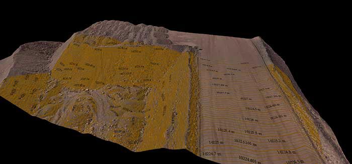
DroneMetrex model showing 10 cm contours
DroneMetrex systems will integrate seamlessly with the standard Maptek mine planning Vulcan software, the Eureka regional mapping system and I-Site Studio laser scan processing software.
Maptek I-Site 3D laser scanning systems provide a natural complement to the aerial data from DroneMetrex, with both systems delivering high quality, accurate data quickly – allowing users to measure and monitor surface changes on a regular basis.
Tom Tadrowski, Managing Director of DroneMetrex and an experienced mapping photogrammetrist and land surveyor, says ‘the support of Maptek and its strong global network will accelerate our growth. The rigorous research and development skills and robust software capability in Maptek will enhance our products and ensure our customers gain maximum benefit from the data captured by our TopoDrone-100 systems.’
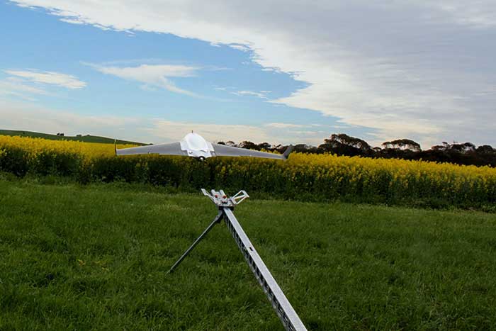
The TopoDrone-100 is a small UAV (unmanned aerial vehicle) able to be operated with minimal training that collects high precision aerial photographs for generating highly accurate terrain models with elevation accuracy of 20 mm.
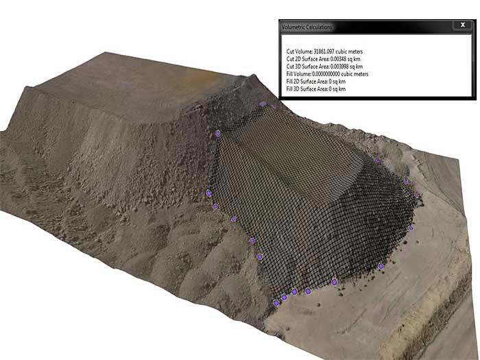
DroneMetrex 3D textured terrain model with volume calculation
Maptek General Manager Peter Johnson says ‘The Dronemetrex technology will be invaluable for many of our customers and will provide new and efficient ways to manage both large projects and regular spatial measurement challenges. This rapid data acquisition capability will deliver immediate rewards to the resources industry’.
About DroneMetrex
DroneMetrex provides a complete solution to capture and process photogrammetric data for mapping large areas such as mine sites and stockpiles. The TopoDrone-100 captures detailed photogrammetric data with unparalleled accuracy, providing an efficient and effective solution for safely acquiring survey data. Outputs include photomosaics, digital terrain models and digital surface models which can be fed into the design and planning process for industrial applications. DroneMetrex is headquartered in Adelaide, South Australia.