Underground Digital Mapping
Paperless workflow enhances productivity
Maptek Data System
Maptek Compute Framework
Maptek Orchestration Environment
Join our early access program to unlock value for your organisation.
Drill & blast management
Scheduling and haulage scenarios
Reliable proximity awareness underground
Dynamic survey surface updates
Mine planning & geological modelling
Connected geological modelling solution
Machine learning assisted domain modelling
Material tracking & reconciliation systems
Laser scanning & imaging
Point cloud processing & analysis
LiDAR-based stability & convergence monitoring
Derive value from airborne or mobile sensor data
Paperless workflow enhances productivity
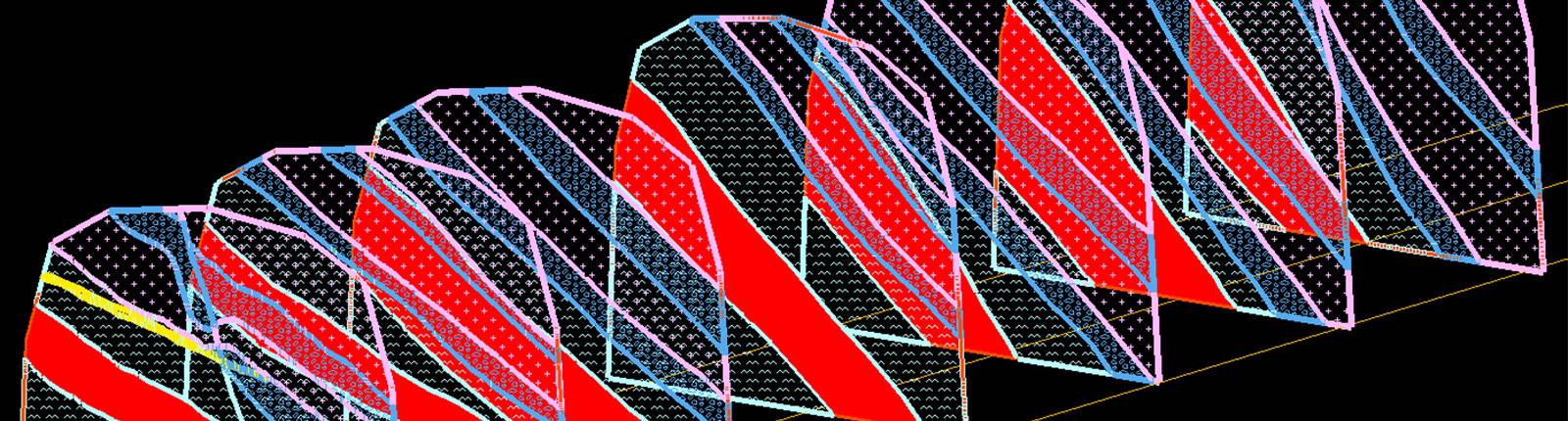
Digital mapping captured directly in Vulcan is a more efficient way to bring accurate mapping data into the 3D digital workspace for interpretation and analysis, allowing dynamic updates in downstream processes such as 3D modelling.
Mapping geological data by hand and converting paper maps into digital format is ineffective and inefficient. Underground production geologists face strict time pressures to capture geological information and make this critical data available in time for downstream processes.
Mapping using traditional pen and paper options or retrospective upload of georeferenced images are both onerous tasks that take considerable time. Scanning and digitising face maps is too time consuming to allow true integration of face mapping data in a fast paced and dynamic production environment.
Digital mapping is proven to take one-third of the time compared to older methods. Capturing lithological, mineralisation and structural information digitally in real-time greatly enhances geologists’ ability to provide accurate and up-to-date geological interpretations to guide production.
The digital solution allows geologists to map directly into Vulcan in the field using a tough tablet. CAD lines and polygons can be drawn over georeferenced scan data or images to quickly and clearly illustrate geology. Record attributes such as grades, and capture structure types alongside notes and measurements that are written back to the corporate database. Automated calculation of weighted face grades while at the face minimises the potential for misclassification of material.
Time savings - The map is created digitally in Vulcan on a tablet underground and synchronised directly into a SQL database on the network, removing all of the post-processing work.
Uses Vulcan - Familiar and easy to implement with existing Vulcan processes.
Integrated geological modelling workflow - Easily flag and extract domain contact points directly from the face map ready for updating geological models.
Data integrity - Synchronising mapping data into a SQL database allows for central storage of all face mapping data, allowing for corporate backup and data management practices.
Streamlined workflow - Exporting face maps directly out of SQL into layers in Vulcan means all mapping data is quickly and easily available to senior and resource geologists for interpretation and analysis.
Flexible - Digital mapping tools are easily customised to ensure compatibility with your requirements.
Working with Maptek to develop and implement the solution at Telfer has been a pleasure; both parties understand and are driven to improve the processes and tasks essential to the mine geologists. The solution is well thought out, easy to use and efficient.
ReCAPTCHA has failed to load! Try reloading the page to submit this form. ReCAPTCHA no se ha podido cargar. Intente volver a cargar la página para enviar este formulario. Não foi possível carregar ReCAPTCHA. Tente recarregar a página para enviar este formulário. Не удалось загрузить ReCAPTCHA. Попробуйте перезагрузить страницу, чтобы отправить эту форму.
We use cookies to enhance your browsing experience and analyse our traffic. By clicking "Accept all", you consent to our use of cookies. You can customise your cookie preferences by clicking 'Customise Preferences'.
We use cookies to enhance your browsing experience and analyse our traffic.
Our website may store cookies on your computer in order to improve and customise your future visits to the website. By using cookies, we can track information about your usage of the site and improve your experience with anonymous and aggregated user data.
Review our Privacy PolicyEssential for the website's functionality, without which the site cannot operate smoothly.
Remember user preferences and choices to provide a more personalized experience.
Collect data on how users interact with the website, helping to improve user experience.
Used to deliver targeted advertisements to users based on their browsing behavior and preferences.