Maptek PointModeller
Derive value from airborne or mobile sensor data
Maptek Data System
Maptek Compute Framework
Maptek Orchestration Environment
Join our early access program to unlock value for your organisation.
Drill & blast management
Scheduling and haulage scenarios
Reliable proximity awareness underground
Dynamic survey surface updates
Mine planning & geological modelling
Connected geological modelling solution
Machine learning assisted domain modelling
Material tracking & reconciliation systems
Laser scanning & imaging
Point cloud processing & analysis
LiDAR-based stability & convergence monitoring
Derive value from airborne or mobile sensor data
Derive value from airborne or mobile sensor data
PointModeller Contents
Table of Contents
Related Pages
Support & Documentation
Table of Contents
Related Pages
Support & Documentation
Maptek develops smart, easy to use software across quarry, aggregates, civil engineering and mining applications. If you collect point cloud data using a drone or other sensor then you need PointModeller, the latest point cloud processing solution.
PointModeller is ideal for converting drone or other lightweight, mobile sensor point cloud data into deliverables for civil, topographic, quarry and aggregate operations.
Featuring powerful 3D visualisation, smart filtering and interactive manipulation tools, PointModeller translates your 3D point clouds into actual deliverables.
Intuitive, powerful tools help manage stockpile inventory through accurate volumetrics, create topographic or 3D surfaces and track digging conformance.
Do you have a complex, detailed point cloud? Don't know how to extract key deliverables? Increase your productivity and optimise your workflow in quarrying, civil or topographical applications with PointModeller.
Featuring smart filtering and interactive manipulation tools,
PointModeller translates your 3D point clouds into actual deliverables
Featuring smart filtering and interactive manipulation tools, PointModeller translates your 3D point clouds into actual deliverables
Cost-effective subscription
Cost-effective subscription package for any drone or mobile sensor user,
providing decision support capability for your project
Combine data
Combine data from a variety of sources for earthworks, civil engineering,
mining, quarry or aggregate operations
Export deliverables
Export deliverables to CAD or mine design formats to apply to other processes
Expand capabilities
Expand capabilities with a range of powerful survey application add-ons
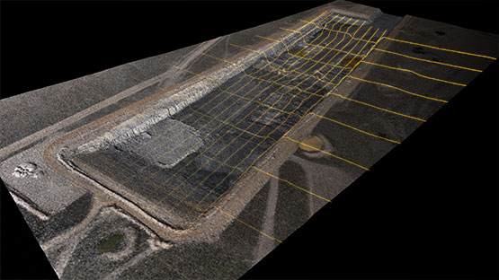
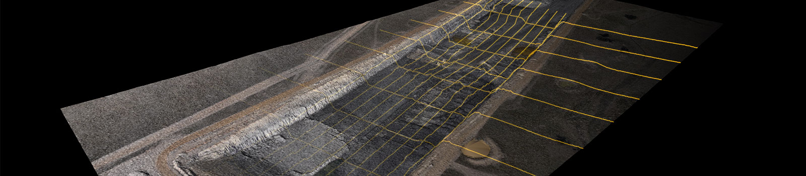
Convert 3D points into deliverables
Convert 3D points into deliverables to calculate surface and solid volumes, run
conformance to design and create smart lines for toe/crest
.las, .laz, .e57, .obj or text files
Supports all .las, .laz, .e57, .obj or text files and exports deliverables in
standard formats
Smart registration tools
Smart registration tools support above ground and underground data
Easy to use coordinate system
Easy to use coordinate system tools to translate data correctly
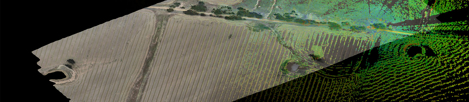
Combine data from your digital sensors and export deliverables for CAD and design tasks
Extend your survey applications with our geotechnical, design conformance and reporting add-ons.
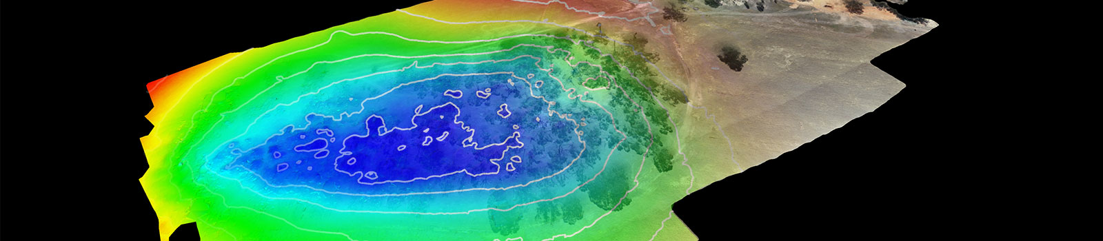
Powerful analysis and mapping tools help manage risk in surface and underground mines.
Upload images from drone or UAV to extract extremely detailed point clouds.
A new ribbon menu including registration, filtering and modelling tools dedicated to underground survey applications.
Compare design surface to as-built and other surfaces, export PDFs of cross-sections and volumes showing conformance.
Report on bench face angles and catch bench widths. Determine if wall angles and catch bench widths need adjusting for safe, economic mining.
Ensure accurate data flows through to production for improved haul road design, mine processes and safety.
The Geotechnical Suite add-on enables accurate, informative geotechnical analysis and reporting to guide mine design and planning decisions.
Reconcile rock bolt distribution and effectiveness for improving safety underground.
Visualise and analyse the fragmentation of a blast to identify wall stability issues, and improve processes such as haulage and mill throughput.
ReCAPTCHA has failed to load! Try reloading the page to submit this form. ReCAPTCHA no se ha podido cargar. Intente volver a cargar la página para enviar este formulario. Não foi possível carregar ReCAPTCHA. Tente recarregar a página para enviar este formulário. Не удалось загрузить ReCAPTCHA. Попробуйте перезагрузить страницу, чтобы отправить эту форму.
We use cookies to enhance your browsing experience and analyse our traffic. By clicking "Accept all", you consent to our use of cookies. You can customise your cookie preferences by clicking 'Customise Preferences'.
We use cookies to enhance your browsing experience and analyse our traffic.
Our website may store cookies on your computer in order to improve and customise your future visits to the website. By using cookies, we can track information about your usage of the site and improve your experience with anonymous and aggregated user data.
Review our Privacy PolicyEssential for the website's functionality, without which the site cannot operate smoothly.
Remember user preferences and choices to provide a more personalized experience.
Collect data on how users interact with the website, helping to improve user experience.
Used to deliver targeted advertisements to users based on their browsing behavior and preferences.