When uncertainty is a good thing
In a non-scientific context, the word uncertainty implies misgiving, doubt and apprehension. In geoscience, knowing how much uncertainty surrounds your model is a good thing!
A geological model is based on the information available plus the geologist’s interpretation of how that information is connected. Different information and different interpretations lead to different models. The differences may or may not be particularly significant but contribute to uncertainty around the model. It is useful to be able to measure that uncertainty.
To report a resource from a geological model requires three components – volume, density and grade or quality.
This model should portray the best understanding of geological processes and observations. However, a volumetric interpretation of geological observations is only as good as the knowledge, experience, biases and patience of the geoscientist building the model.
In reality, several possible interpretations could be generated by multiple geologists, and as such geological uncertainty is just as important as grade uncertainty.
Why uncertainty gets overlooked
This geological uncertainty often gets overlooked, primarily because unlike grade uncertainty, there is no easy way of capturing or communicating it.
When information is static, a model has a long shelf-life, but when new information becomes available it is important to incorporate that in the model. However, if models are revised only every three to six months the model being used for operational purposes may be quite outdated. Geologists spend their time putting together presentations rather than interpreting and validating the data and the models based on it.
This limitation affects the geologist’s ability to test geological hypotheses and makes it difficult to increase their understanding because using current methods they only have time to rerun the same models.
We discovered very early that our revolutionary machine learning solution DomainMCF was highly efficient at predicting geological domains. The revolutionary approach requires little in the way of input parameters, and makes it easier for geologists to churn out meaningful revisions of their models in a timely manner.
Importantly, it also generates models that include a measure of uncertainty. The uncertainty can then be used to make more informed operational decisions – decisions like applying the drilling budget, where it makes sense to target areas of high uncertainty rather than drilling out a grid in a zone of geological homogeneity.
Reducing modelling time from weeks to minutes
Let me share a case history with you from the Lisheen base metal mine in Ireland, which operated continuously for 17 years. Running the Lisheen drilling data through DomainMCF presented several possible interpretations for geological domain boundaries.
You may be wondering how receiving different interpretations actually helped. Just as three different geologists can interpret the data in different ways, machine learning can emulate the same process but with several orders of magnitude in speed improvement.
All of the different solutions honour the data, and the recorded difference in the ore volumes between methods was only 4%, which goes to show that the underlying uncertainty that exists in most geological settings doesn’t really matter. But it is important to KNOW that. Sometimes it really does matter.
Each model generated for this case history took 10 minutes to complete using DomainMCF. When I contacted the former Mine Geologist at Lisheen, he told me that 10 years ago a model required a week’s worth of effort.
So now we’ve got models run more efficiently, with comparative results and with the uncertainty factor known.
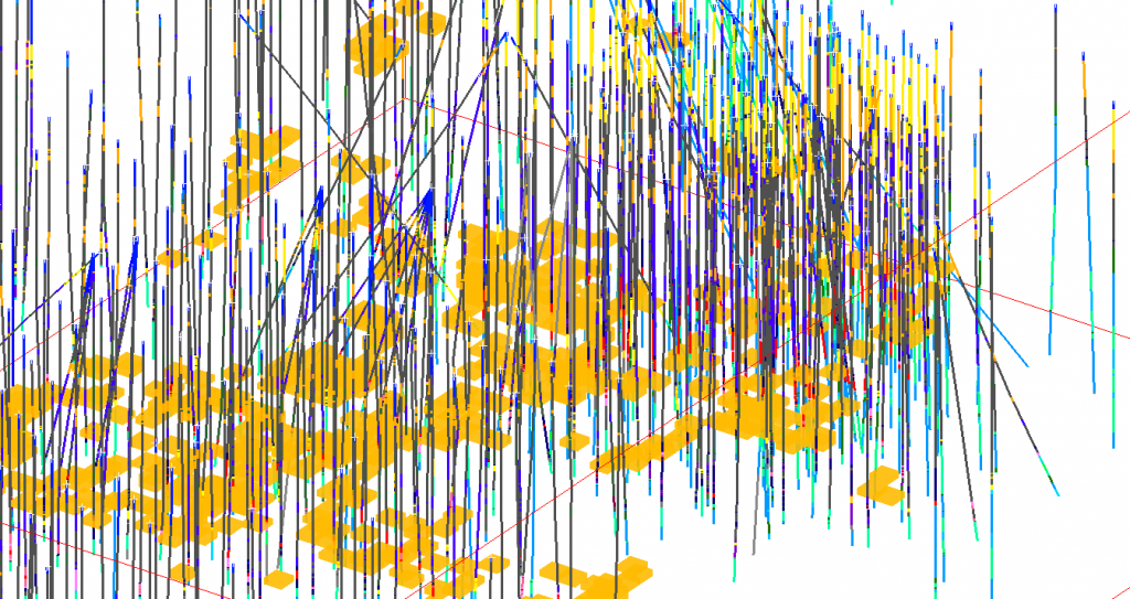
This 3D perspective view of the surface drilling for the Lisheen orebody provides clues to the challenges inherent in interpretation. Even though the drilling appears closely spaced, the rapidly changing geological contacts in each hole provide a level of uncertainty as to the interpretations between adjacent drillholes. In this deposit the majority of the geological uncertainty related to terminal margins of the mineralised horizon. The yellow-orange blocks show spatial distribution of the areas of uncertainty. These result in an overall +/- 6% variation in volume within a suite of DomainMCF predictions.
How can this uncertainty knowledge be put to use?
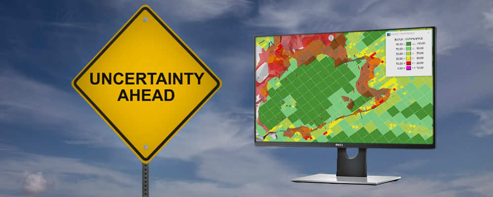
Uncertainty can be used to better quantify confidence when assessing resources and reserves stated compliant to the JORC code, reducing subjectivity. Using the Lisheen data we were able to quantify volumetric uncertainty for the geological domains generated from the widely spaced exploration drillholes.
The models of the main mineralised body exhibited a volumetric variation of 12% between the most optimistic prediction of the geological domains and the most pessimistic interpretations.
This is an important observation, as a variation of this magnitude will affect the resource statement.
Instead of a statement such as ‘1 million tonnes at a grade of x’, the more appropriate wording would be ‘1 million tonnes (+/- 6% or +/- 60,000 tonnes) at a grade of x’.
The alternative statement provides mine planners and potential investors with a quantitative assessment of the risk due to geological uncertainty
Webinar: Towards greater certainty in resource modelling
Machine learning is already providing breakthroughs in rapid, accurate resource modelling. Now Maptek can reveal the unique ability to record the degree of uncertainty around resource predictions.
Click below to learn how being transparent about uncertainty actually improves confidence in your work.