Underground Tools
Add-on
PointStudio
PointModeller
Maptek Data System
Maptek Compute Framework
Maptek Orchestration Environment
Join our early access program to unlock value for your organisation.
Drill & blast management
Scheduling and haulage scenarios
Reliable proximity awareness underground
Dynamic survey surface updates
Mine planning & geological modelling
Connected geological modelling solution
Machine learning assisted domain modelling
Material tracking & reconciliation systems
Laser scanning & imaging
Point cloud processing & analysis
LiDAR-based stability & convergence monitoring
Derive value from airborne or mobile sensor data

Underground Tools Contents
Table of Contents
Related Pages
Support & Documentation
Table of Contents
Related Pages
Support & Documentation
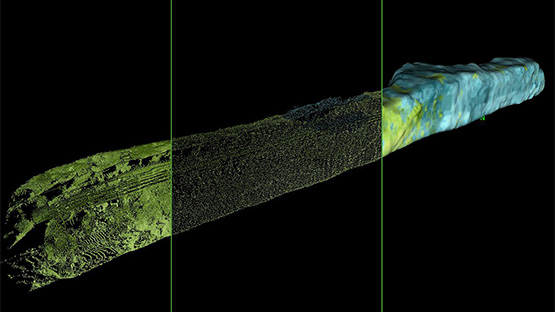
A new dedicated ribbon menu now contains all of the functionality to support efficient underground survey applications. Easily import, register, filter, remove services, create solids, centrelines and boundary outlines of scan data.
Streamlined workflow: Register, filter and model underground scans
Smart registration: Cloud to cloud registration; target recognition and registration
Intuitive tools: Create a hull surface and extract centrelines and plan view boundaries
Scene visualisation: Easily filter out underground services and mesh to provide a ‘clean’ point cloud for modelling
Safety support: Compare designed and actual solids or surfaces to view underbreak and overbreak
Automated reporting: Generate and share reports in minutes
ReCAPTCHA has failed to load! Try reloading the page to submit this form. ReCAPTCHA no se ha podido cargar. Intente volver a cargar la página para enviar este formulario. Não foi possível carregar ReCAPTCHA. Tente recarregar a página para enviar este formulário. Не удалось загрузить ReCAPTCHA. Попробуйте перезагрузить страницу, чтобы отправить эту форму.
We use cookies to enhance your browsing experience and analyse our traffic. By clicking "Accept all", you consent to our use of cookies. You can customise your cookie preferences by clicking 'Customise Preferences'.
We use cookies to enhance your browsing experience and analyse our traffic.
Our website may store cookies on your computer in order to improve and customise your future visits to the website. By using cookies, we can track information about your usage of the site and improve your experience with anonymous and aggregated user data.
Review our Privacy PolicyEssential for the website's functionality, without which the site cannot operate smoothly.
Remember user preferences and choices to provide a more personalized experience.
Collect data on how users interact with the website, helping to improve user experience.
Used to deliver targeted advertisements to users based on their browsing behavior and preferences.