Maptek PointStudio

Maptek Drive

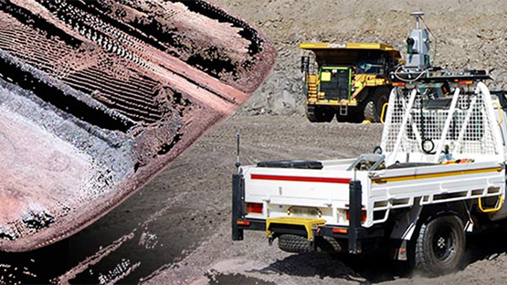
Maptek Drive allows the continuous acquisition of laser scan data with a Maptek laser scanner mounted on a moving vehicle. Mining, quarry and civil operations can efficiently survey stockpiles, highwalls and haul roads.

Maptek Drive is suitable for all mining or civil survey tasks. It is an efficient, accurate method for stockpile volumetrics, end-of-month reconciliation, top of coal and highwall mapping thanks to the Inertial Navigation System. Scans are automatically georeferenced and displayed in the vehicle cab to ensure adequate coverage and density of points.

Maptek Drive is more flexible and cost-effective than dedicated mobile scanning systems. Workflows are tailored to suit common mining deliverables.

Maptek laser scanners can also be mounted on common site vehicles without the INS for deployment in stop-go scanning mode.

Flexibility

  • More cost effective and flexible than comparable mobile systems
  • Use the same laser scanner for surveying stockpiles, open pits, quarries, corridors and roads, and mapping geology
  • Use the same laser scanner for tripod, vehicle-mounted stop-go, rail or hatch-mounted survey, and continuous scanning

Productivity

  • Data points automatically registered into real world coordinates
  • Smart registration and visualisation tools
  • Stockpile reconciliation workflow tailored for mining, bulk handling and quarry operations
  • Capture top of coal for reconciliation with the geological model
  • Stationary scans collect survey data for updating surface models

Speed & safety

  • Rapid data collection, with additional speed using dual window system
  • Multiple survey applications accomplished simultaneously
  • Minimise interruption to site activities

Maptek survey technology keeps bulk earthworks project safely on track

Maptek mine measurement technology helps ensure bulk earthworks meet design for the Western Sydney International Airport.

Read the case study

Maptek Drive Brochure
 

Introducing Maptek Drive

  • Applications
  • Stockpile reconciliation
    Top of coal survey
    Haul road survey
    Highwall mapping
    Pit surface update
    Bulk handling material volumetrics