
September 2023 Issue Index
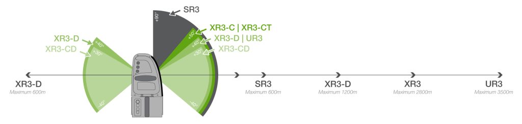
Ultra long range laser scanner
The latest Maptek laser scanner maintains high end engineering specifications as it responds to market needs for monitoring and survey in very large open pits.
The Maptek UR3 mkII laser scanner features the high end engineering specs of the R3 mkII series with an extended range ideal for larger pits. Sites can use the ultra long range scanner to monitor highwall, bench, ramp and tailings dams, and take advantage of its versatility for numerous mine survey applications.
‘Implementing one piece of kit for site survey and monitoring is important in the current market,’ commented Global Product Strategy Manager Jason Richards.
‘Risks rising from staff turnover and fast-paced operational demands can be offset somewhat by a single system that acquires and generates value from data as quickly, safely and accurately as possible,’ he said.
‘The Maptek XR3 was designed for survey and geotechnical data acquisition. Stronger demand globally for monitoring over a longer range has driven our recent R&D effort, resulting in the first UR3 production units shipped to our international regions for field trials in April,’ added Richards.
Mining operations can purchase the UR3 as a standalone laser scanner or bundled with the Sentry custom trailer. This includes a power and communications module, cellular and wifi networking, mounting bollard and Sentry software for data acquisition and analysis.
This transportable setup is ideal for accurate 24/7 continuous scanning and monitoring of multiple locations. Site personnel can manage the process entirely remotely and send real-time data to any device on a network for interpretation and analysis.
Mobile systems can be positioned anywhere on the edge of the pit for monitoring, with the laser scanner swapped onto a vehicle mount with Maptek Drive for mobile site survey applications. Maptek laser scanners are also easily mounted on bollards for monitoring fixed locations.
Reliable operation and alarm capability are distinct advantages of laser scanning for monitoring.
The monitoring frequency and thresholds can be set to meet the demands of strategic design and operational planning. Accurate, timely reporting of rapid and gradual movements to geotechnical teams and management helps control risk and safeguard operational environments.
Since the early 2000s, Maptek has developed easy to use systems for spatial mine measurement applications, with a commitment to safety, data reliability and accuracy.
The UR3 is available in standard and cold climate configurations. In extreme climates, the system can be used to continuously monitor at temperatures from -20°C to +50°C, with limited operation down to -40°C.
- Maximum range of 3500 metres ensures the new UR3 laser scanner is suitable for monitoring and survey in large open pits
- Maptek laser scanners are engineered to overcome dust penetration and diurnal fluctuations in data to ensure accurate, reliable data for managing risk
- Improved angular accuracy in the latest laser scanner provides better data coverage on the fringes of scenes being monitored for surface movement