March 2024 Issue Index
Accurate data interpretation
An open cut mine in Queensland maximised coal recovery through accurate data interpretation and structural modelling using measurement-while-drilling data.
Hail Creek Mine, owned and operated by Glencore Coal Assets Australia, is an open cut mining operation in central Queensland, Australia. Since 2003, the mine has been a key player in producing metallurgical and thermal coal for the export market.
Located within the Permian strata of the Bowen Basin, known for its substantial coal-producing intervals, Hail Creek Mine utilises dragline, truck and shovel methods in both strip and terrace mining sections across the deposit.
The operation produces premium low ash hard coking coal, higher ash hard coking coal, and high ash thermal coal for export. The site’s strategic location contributes to its significance in the industry.
Improving mining efficiency and maximising coal recovery through the reduction of coal loss and dilution is a primary focus in Glencore coal mines.
Measurement-while-drilling (MWD) data, including penetration rate and torque, are crucial for identifying coal seam roofs and thick sandstone overburden units.
Hail Creek undertakes extensive short-term pre-production drillhole geophysical logging to unravel the complexity of the geological structures.
Maptek GeologyCore interpretation tools offer viable solutions to the challenges associated with interpreting the data. The geology team managed to reduce almost 60% of blast hole geophysical logging in certain areas of the pit, replacing it with MWD data interpretations.
With more accurate, faster interpretations from GeologyCore, it was possible to use MWD data in conjunction with Maptek Vulcan integrated stratigraphic modelling features. This allowed the combination of MWD with exploration data and its use in the site modelling process.
Identifying boundaries
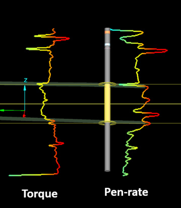
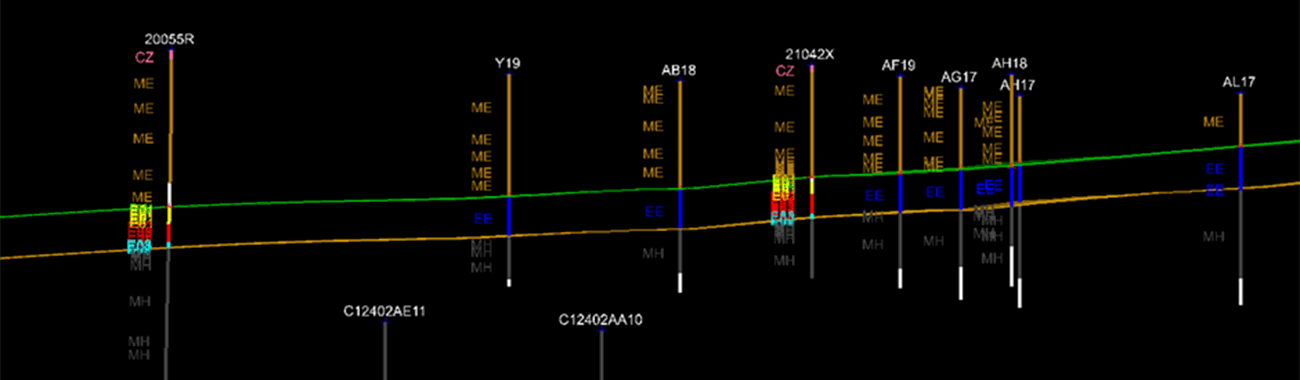
MWD variables, such as penetration rate and torque, were used to identify coal seam roof, floor and thick sandstone overburden units (Figures 1 & 2).
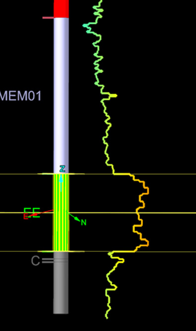
A main goal was to clearly identify coal roof and thick sandstone unit boundaries, with a 15-20 cm maximum error per pick. Using the lithology targeting tool, coal seams and sandstone overburden units were efficiently bulk picked (Figure 3), saving considerable time in correcting drillholes.
The visualisation tool played a pivotal role in accurately distinguishing between coal and sandstone units.
The ability to optimise a parameter range to achieve a better scale when two variables such as penetration rate and torque are plotted against depth significantly improved the accuracy of coal seam roof identification.
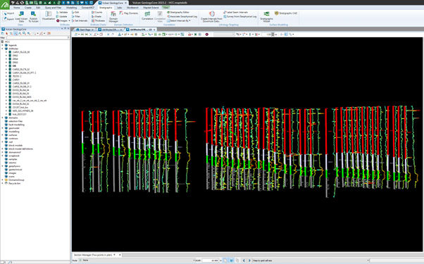
Corrected drillholes are combined with the site exploration database for more accurate results in Vulcan integrated stratigraphic modelling (Figure 4).
Implementing GeologyCore reduced costs by minimising geophysical logging and mitigating blast damage to coal through precise modelling. The overall modelling process was faster and more efficient. Site geologists found the software user friendly, facilitating fast and easy training.
The positive impact of GeologyCore extends to multiple aspects of geological modelling at Hail Creek, contributing to enhanced efficiency and cost-effectiveness.
Thanks to
Kenneth Wijeratne
Mine Geologist
Glencore
Modelling tools
Maptek GeologyCore provides a dynamic workflow for validating drillhole databases, assigning domain codes and generating geological models directly from drillhole and other data.
Data is easily loaded from Vulcan and published back to Vulcan when modelling is complete. A dynamic interactive interface streamlines the generation of complex multi-domain models.
Users can access multiple modelling techniques – Grid, Implicit, Vein or DomainMCF – in a single workflow. Other features include a visual interface for data preparation and validation, and an upload/ download mechanism for DomainMCF.
The GeologyCore 2024 release features enhancements to how intrusives are handled, a new snapping mode for Implicit Modeller, Fault Manager and Intrusives in Modelling Manager. Improved network relationships panels, additional splitting options for fixed lengths from collar and by elevation, and output boosted by automated reporting are other benefits.
Vulcan Integrated Stratigraphic Modelling creates reverse and normal faulted stratigraphic models using defined dip and throw, without requiring solid triangulation fault domains. Strings or fault surfaces can be used as input. Users can directly incorporate data points from drillholes or CAD input via a hybrid modelling method.
- Visualisation tools played a pivotal role in accurately distinguishing between coal seams and sandstone units for Glencore Hail Creek
- GeologyCore and Vulcan reduced costs by minimising geophysical logging and mitigating blast damage to coal through precise modelling
- Site geologists now experience an overall faster and more efficient geological modelling process to meet the corporate focus on reducing coal loss and dilution
Maptek GeologyCore
Vulcan GeologyCore was first delivered in 2021 as an inclusion for specific Vulcan licence types to support geologists in their daily work.
With the expansion of modelling features and an advanced workflow that connects geologists with multiple modelling methods, the solution is now rebranded and offered as Maptek GeologyCore, a standalone product.
GeologyCore is available as a subscription licence with dedicated add-ons for geotechnical, design conformance and working with seismic data.