June 2020 Issue Index
Slope stability risk management
Maptek laser scanner technology is ideal for volumetric survey, geological and geotechnical data analysis, and tactical and strategic slope deformation monitoring.
Letšeng Diamond Mine is an open pit mine in the north of the Kingdom of Lesotho. At 3100 m above sea level, it is one of the highest altitude diamond mines in the world, and is famous for the production of large, top quality diamonds.
Two kimberlite pipes bearing low-grade ore are currently being mined as consecutive pushbacks via conventional mining methods.
Safety is very important to the operation, and Letšeng is keen to embrace technical innovation to ensure timely and accurate detection of unstable slopes.
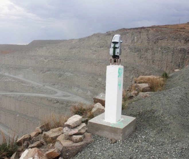
A Maptek XR3 laser scanner is used to acquire point cloud data for geotechnical analysis, volumetric calculations and rockfall assessment.
Compared with traditional methods laser scanning provides direct, detailed 3D geometric mapping, quick and accurate measurements and significantly faster data processing, as well as cost reductions.
Letšeng Geotechnical Manager, Nkopane Lefu commented that the system was very user friendly and that Maptek staff provided responsive support. ‘Working with Maptek is a good experience.’
Geotechnical data analysis
The 3D technology can deliver the detailed and dense data required for geotechnical analysis, creating a high resolution point cloud over large areas in several minutes.
Laser scanning has improved the mapping database because now all areas including inaccessible and unsafe areas can be covered.
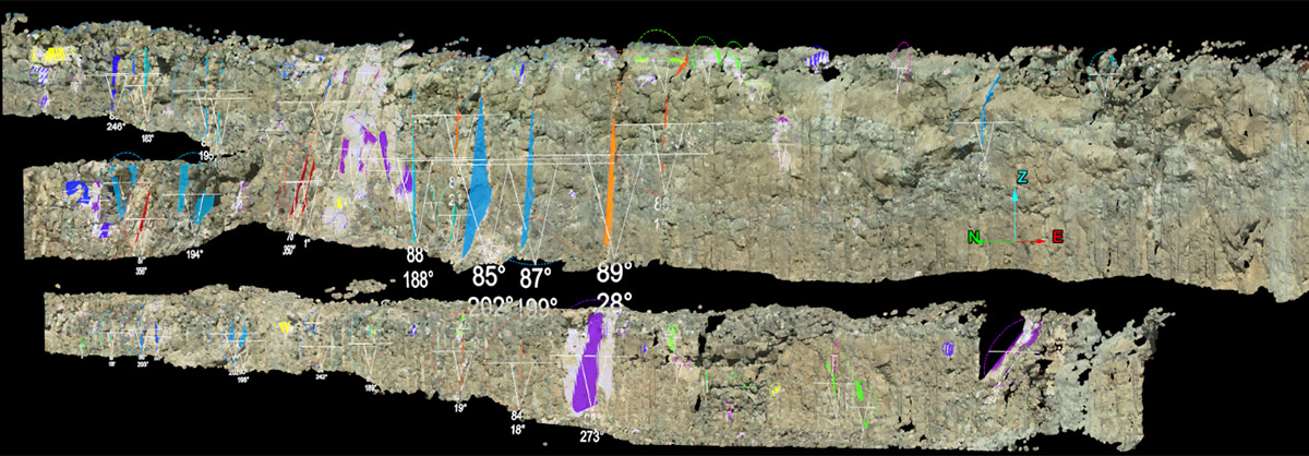
Discontinuity properties including orientation, spacing, surface roughness and persistence can be determined remotely and accurately over long distances.
The scans are imported into Maptek PointStudio software for analysis. Scans can all be georeferenced at the same time, and after filtering of trucks, vegetation, snow or dust, a complex 3D surface is created for geotechnical mapping.
Various methods for extracting discontinuity data are used, including automated techniques that examine orientation trends and a semi-automated method that depends on user structural interpretations of specific features.
Manual point cloud analysis gives the geotechnical engineer the same control as in the field, with the benefit of unrestricted data coverage.
On the other hand, the automated method is quick, uses more detailed data and reduces the potential bias of the geotechnical engineer. Every visible joint plane is assessed and characterised.
The orientations of the geological defects are then plotted on the stereonet to analyse and determine discontinuity orientations and major joint sets. The data can also be exported as a csv file into rock mass analysis software.
PointStudio geotechnical tools allow for accurate measurement of surface roughness. The selected surface is divided into grids depending on user preference. The results are then used to determine the joint roughness coefficient (JRC).
Data from one Letšeng pit was used for kinematic analysis to determine possible modes of failure, by analysing the relationship between the major joint sets/planes of individual joints, the slope and the basic friction angle.
The results indicated that possible localised failures are restricted to bench scale and inter-ramp failure is not likely. The data can be used in limit equilibrium and numerical modelling packages for detailed slope stability analysis.
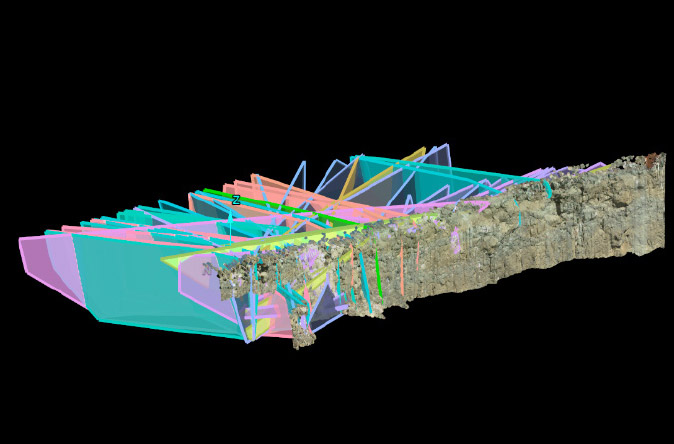
Mapping of blast blocks is vital for blast design to minimise highwall damage and to achieve controlled and desired fragmentation.
At Letšeng, highwall control is of high priority because of the recently implemented steep slope. Every trim block is mapped and geological information is analysed for geological defects and rock mass strength. PointStudio can extrapolate joints throughout the trim blocks to predict blast integrity.
Slope monitoring
Open pit mining best practice calls for timely detection of potential rock slope instabilities and effective management of identified instabilities, making both strategic and tactical slope monitoring an integral part of any mine program.
Letšeng deploys prisms for long-term deformation monitoring, radar in critical areas for tactical monitoring, and the XR3 laser scanner for hazard identification, strategic and tactical monitoring.
The scanner is used for both periodic and continuous slope monitoring. Scans must be taken from a fixed point for periodic monitoring, so beacons are constructed strategically around the pits. Scans are imported into Maptek Sentry office software for data processing and analysis.
Continuous monitoring is conducted using Sentry field software hosted in the Sentry DMS system in a deployable trailer. The DMS comprises a Maptek XR3 laser scanner, built-in tripod, solar panels, weather station, standby generator and Wi-Fi antenna mast for communications. Scans are downloaded automatically into the built-in computer for processing.
Output data includes displacement, velocity, moisture intensity and inverse velocity time graphs The behaviour of each graph can be related to environmental factors such as rainfall, wind direction and intensity. Trigger alarms can be set and notifications sent through local mine networks.
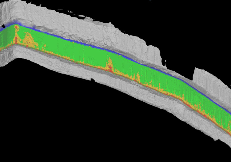
Benches are the fundamental building blocks of the pit slope and their geometry and behaviour often controls the inter-ramp and hence the slope design. Letšeng has implemented rigorous quality control and quality assurance on the highwalls to ensure that the required catchment is achieved.
The 3D point cloud data is used to compare the actual slope to design, which quantifies the frozen toes as well as crest damage. Crest compliance is calculated by comparing actual and design crestline, while toes are determined by comparing the actual bench face with design. Intensive rock barring is performed on the crest above where it has been compromised beyond an allowable 10 metres.
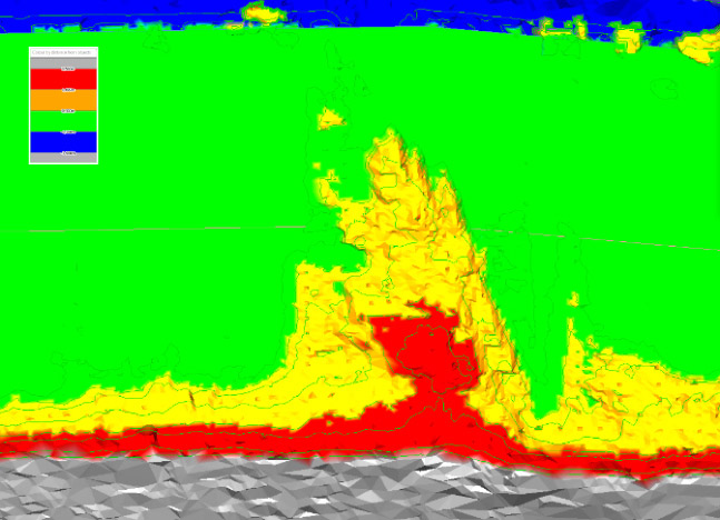
Overall slope compliance is assessed in PointStudio where cross sections of the actual slope are overlain on the designed slope.
Since acquiring the Maptek XR3 laser scanner geotechnical engineers at Letšeng can collect significantly larger datasets more safely. The smart PointStudio geotechnical tools are used to characterise geological defects and determine possible failure modes. Sentry technology is applied in slope deformation monitoring as well as mining compliance measurements.
Management can now make more informed safety-related decisions based on slope behaviour.
Thanks to
Nkopane Lefu
Geotechnical Manager
Letšeng Diamond Mine
- Letšeng Diamond mine needed a solution that delivered timely and accurate detection of unstable slopes
- Laser scanning improved mapping coverage and speed of georeferenced results alongside geotechnical output
- Laser scanning combined with a Sentry monitoring system allows management to make more informed safety-related decisions based on slope behaviour