September 2019 Issue Index
Digital geotechnical cell mapping
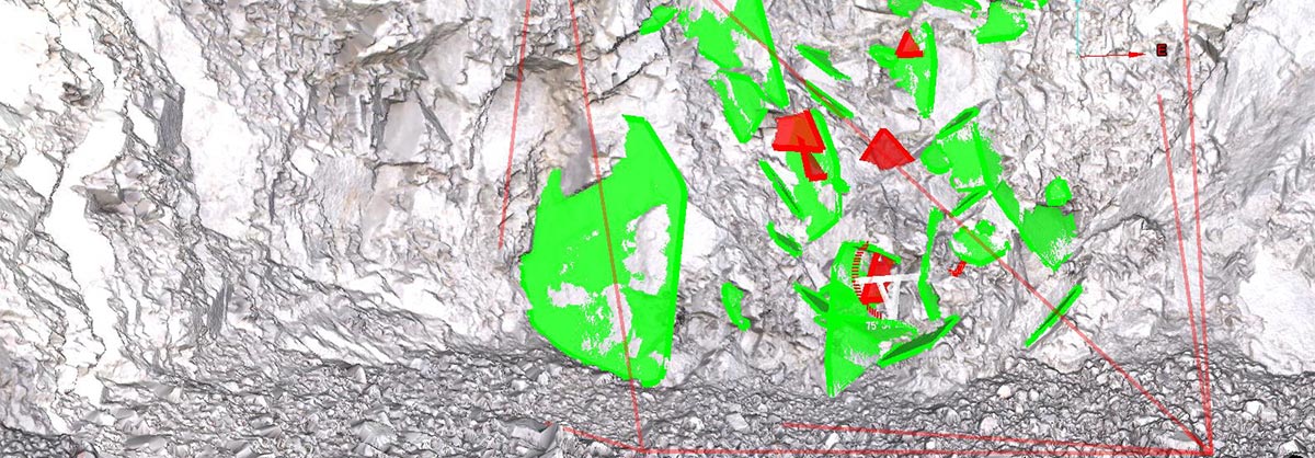
Maptek PointStudio CAD-based visualisation and digitisation tools have digitally replicated conventional cell mapping at a mine in Arizona.
Maptek spatial technology has proven its benefits over conventional cell mapping techniques during a comparison at Freeport McMoRan – Bagdad Mine.
Bagdad is an open-pit copper and molybdenum mining complex about 100 miles northwest of Phoenix, Arizona. The Bagdad operation consists of a 75,000 metric ton-per-day concentrator, an SX/EW plant that can produce up to 32 million pounds per year of copper cathode from solution generated by low-grade stockpile leaching, and a pressure–leach plant to process molybdenum concentrate.
Cell mapping is a systematic field technique used to collect geological data, with an emphasis on measuring and recording rock fabric data from highwalls for geotechnical analysis.
Highwalls are divided into cells of equal dimension from a defined height and width, and structural features within the cells are grouped into sets that share similar orientations, allowing for complete geological sampling.
Freeport McMoRan used Maptek terrestrial LiDAR and PointStudio geotechnical cell mapping tools to compare conventional cell mapping techniques with the digital method.
The comparison showed that Maptek 3D laser scanners and PointStudio software can provide more accurate and consistent cell mapping data, delivered through a far safer workflow.
The digital method involves taking high-resolution 3D laser scans and photographs of the highwall and analysing the data using PointStudio.
Interpretation is based on simultaneously examining the 3D surfaces and photographs to get a comprehensive understanding of the highwall.
‘The scan produces a really detailed point cloud with a point spacing of about one inch, essentially replicating the highwall relief as you see it in the field,’ 3D Geological/Reserves Modeler at Freeport McMoRan, Josh Cobb explained.
The structural features – such as discontinuities, fractures and faults – are generated and recorded in a digital version of the traditional cell mapping data sheet.
The conventional in-field method takes two people about 15 to 20 minutes to measure out and spray the boundaries for a 10-cell run.
The digital method takes a similar time but can be done from the safety and comfort of an office by a single person using PointStudio.
Simple polyline traces of crest and toes are created manually in the software and then the cells are generated automatically based on input information. Cell mean face orientations can be automatically calculated based on the selection of three points and the data can be exported as a CSV file.
Stereonet plot comparisons show that both methods identify main sets, the data statistics are similar, and the digital method virtually replicates the experience of sighting with a Brunton compass.
‘You get similar data with greater accuracy and consistency using the digital method, and the process becomes quicker and more efficient over time and experience with the software,’ said Cobb.
Workers no longer need to spend significant time within close proximity of the highwall.
Extreme heat, cold or rain can limit highwall access and also create hazardous environments, with the risk of heat exhaustion and potentially dangerous driving conditions within a pit.
‘The digital method removes those elements from the equation,’ commented Cobb.
‘You only need one person for the digital method, as opposed to two for the conventional method, and the only time you really need to go down into the pit is to take pictures of the highwall.’
Digital cell mapping has proved to produce accurate and consistent results for geotechnical analysis.
Thanks to
Josh Cobb
3D Geological/Reserves Modeler
Freeport McMoRan – Bagdad Mine
- Cell mapping is a systematic field technique used to collect geological data, with an emphasis on measuring and recording rock fabric data from highwalls for geotechnical analysis.
- Comparison with conventional techniques showed that Maptek 3D laser scanners and PointStudio software can provide more accurate and consistent cell mapping data, delivered through a far safer workflow.
- The digital method involves taking high-resolution 3D laser scans and photos of the highwall and analysing the data using PointStudio.