September 2019 Issue Index
Spatial measurements for drill & blast
Integrated Maptek technology is breaking new ground in drill & blast performance and reconciliation.
Georeferenced spatial data imported into Maptek BlastLogic drill & blast management solution delivers greater understanding of blast execution and results, enabling future blasts to be refined and optimised to reduce costs and increase safety and productivity.
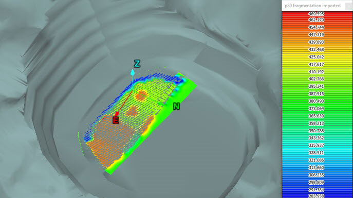
For example, using the Fragmentation Analysis tool in Maptek PointStudio with BlastLogic delivers greater post-blast performance visualisation. This tool takes laser scan data and segments it by automatically identifying individual rock pieces, providing a breakdown of the size of each particle.
Fragmentation information is vital as it affects dig rates, crusher throughput and general efficiency in the mine to mill process.
Any spatial data can be fed into BlastLogic and associated with the blast holes using the spatial measurement tools and used in downstream processes such as reporting.
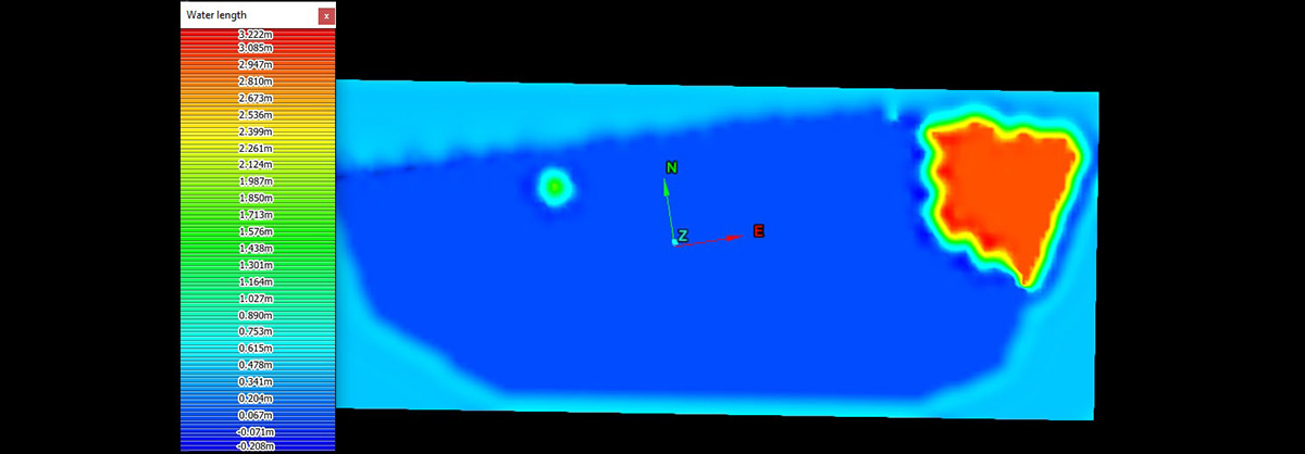
Generating heatmaps showing results of blasts in relation to blast parameters such as design and execution information assists with blast analysis and improvement.
Displaying the information in such a clear visual manner gives engineers a true picture of the results of the blast.
Engineers can investigate the areas where the fragmentation differed from what was expected in planning.
Issues can be identified, such as waterlogged or underloaded areas and resultant choking of the blast, along with areas where the blast was impacted by differing geology or bad or incomplete drilling, or free facing.
Results can guide future blast preparation and execution.
Other indicators of blast performance such as blast heave or cratering can also be brought into BlastLogic as spatial data and associated with the drillholes.
Maptek Specialist Mining Engineer Rahul Suhane says this capability is causing a buzz in the industry.
‘It really is groundbreaking,’ Suhane says. ‘Whenever I visit sites and show engineers these spatial measurement tools they’re really excited by the potential.’
‘Previously this information was only presented as a series of numbers and often when the average is taken everything looks OK. You can’t pinpoint areas where the blast wasn’t optimal and therefore don’t learn about what you’re doing right and what’s going wrong.’
‘Using this spatial data allows sites to get to the root cause of any issues in a particular blast.’
Suhane says this analysis may lead to sites improving their practices by taking steps such as modifying charging algorithms in BlastLogic to ensure water-based explosive is always chosen in areas prone to dynamic or static water.
Post-blast back-break data from PointStudio can be fed into BlastLogic as spatial data to aid geotechnical analysis and to ensure repeatability of successful blasts.
The process of optimising blast performance across planning, design, execution and analysis that Maptek technology provides is not limited to PointStudio and BlastLogic.
BlastLogic charge algorithms and tie up processes, along with vibration and fragmentation modelling, help optimise charge designs.
BlastLogic’s ability to directly interface with supported drill navigation systems allows import of as-drilled data to validate drilling information against design.
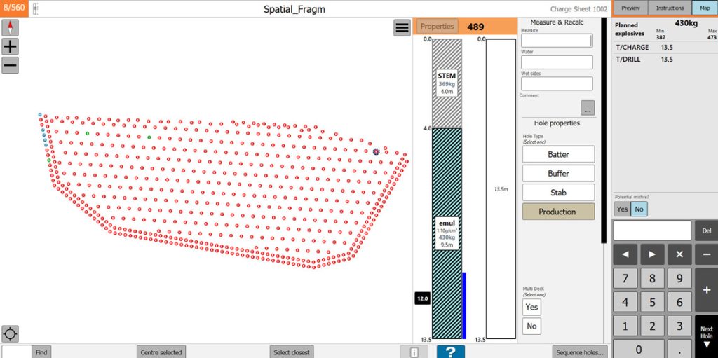
The BlastLogic Tablet application is able to work offline and sites with good network connectivity reap the benefits of near-live data.
The tablet assists with better execution of charge plans by facilitating capture of the hole characteristics such as dipping, water length and temperature information, as well as updating the charge plans based on these characteristics.
In the upcoming BlastLogic 3, this capability has been extended to capture any custom site information per hole to update charges on the tablet.
Maptek continuously invests in research and development to raise industry standards. BlastLogic 3 is set to be delivered on the Maptek Workbench giving greater data integration with Vulcan, including live data editing.
Any changes to blast and CAD data shared between Vulcan and BlastLogic are simultaneously updated, allowing Vulcan drill designs to benefit from BlastLogic’s charging, tie-up and blast modelling tools and simplifying the drill & blast design iteration process.
Industry-leading design tools, integration with third-party systems and digitalisation of drill & blast processes is helping global miners to reduce costs and improve productivity.
Optimal drill & blast design and safe blast execution can ensure value is not left in the ground.
- Georeferenced spatial data imported into Maptek BlastLogic drill and blast management solution delivers greater understanding of blast execution and results.
- Displaying spatial data information as heatmaps gives engineers a clear visual representation of the results of blasts.
- Industry-leading design tools, integration with third-party systems and digitalisation of drill and blast processes help global miners reduce costs and improve productivity.